Percorso Marcia The Municipal District of Cahir — Cashel - Rock an Torabh Walk - Photo
 mlmoroneybb
mlmoroneybb

Utente

© OpenStreetMap contributors
Lunghezza
Lunghezza
8,1 km
Altitudine massima
Altitudine massima
311 m
Dislivello positivo
Dislivello positivo
190 m
Km-Effort
Km-Effort  
10,7 km
Altitudine minima
Altitudine minima
149 m
Dislivello negativo
Dislivello negativo
197 m
Boucle
Boucle
Sì
Data di creazione :
2014-12-10 00:00:00.0
Ultima modifica :
2014-12-10 00:00:00.0

(0 Recensione)

Marcia
Marcia
2h18
Difficoltà : Medio

Scannerizza questo codice QR per aprire il percorso nell'applicazione SityTrail

Applicazione GPS da escursionismo GRATUITA

Logo SityTrail SityTrail

IGN / Istituti geografici

Scarica SityTrail dall'App Store Scarica SityTrail da Google Play

Logo SityTrail SityTrail Plus

Il mondo è tuo

Scarica SityTrail dall'App Store Scarica SityTrail da Google Play Scarica SityTrail da Huawei AppGallery

Chi siamo

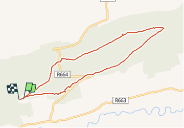
Percorso Marcia di 8,1 km da scoprire a Sconosciuto, County Tipperary, The Municipal District of Cahir — Cashel. Questo percorso è proposto da mlmoroneybb.

Descrizione

A-B. From the mapboard in the green area climb onto the road and go to the Christ the King statue. Follow the red arrow and enter the forestry at the barrier. Note that you are also following blue arrows which are for the longer Millenium Stone Loop. After 50m you reach a Y-junction where the BLUE loop veers right and downhill – but you continue straight following the red arrow. 


B-C. You are now on a forestry roadway. Continue to follow the red arrows along this roadway for 2km to reach a crossroads you rejoin the BLUE loop as it makes its way back from the Millenium Stone. Turn sharp left here. 
         

Profilo altimetrico

Localizzazione

Paese:
Ireland
Regione :
Sconosciuto
Dipartimento/Provincia :
County Tipperary
Comune :
The Municipal District of Cahir — Cashel
Località :
Clonbeg
Partenza:(Dec)
Partenza:(UTM)
555031 ; 5808609 (29U) N.


Chiudi
I miei abbonamenti